

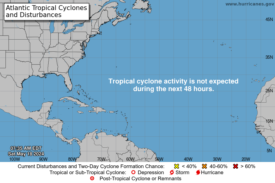
The National Hurricane Center is monitoring four tropical waves on Monday, according to the latest tropical outlook.
No tropical cyclone development is expected over the next two days.
That doesn’t mean the tropics won’t have an impact on Florida this week.
➤ Track all active storms
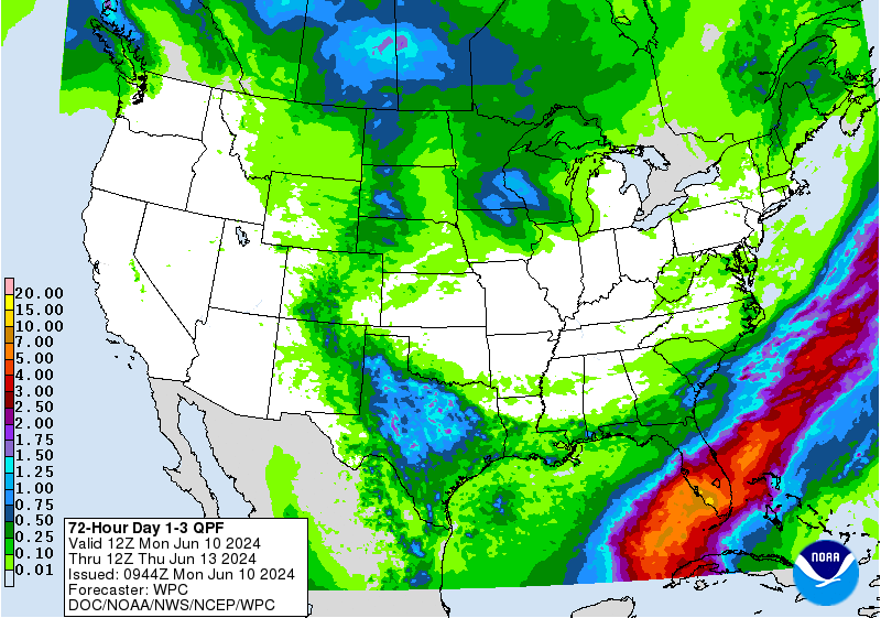
➤ Excessive rainfall forecast
According to AccuWeather, a “burgeoning tropical rainstorm” is expected to bring repeated heavy rain showers to the Sunshine State throughout the week.
Southwest Florida is expected to see the most rain, with 6 to 8 inches expected in Fort Myers. Some areas could see up to 22 inches, AccuWeather said.
“While there is no sign of a tropical system forming and intensifying quickly, there is a chance that the downpours could organize enough to become a tropical system,” AccuWeather forecasters said.
➤ Florida weather: Heat records in the weekend. Now torrential rain is coming our way
The reason for the repeated rain showers throughout the week is that there is nothing in the atmosphere to move it.
“With no other approaching storms or strong jet stream winds pushing the storm, the rain storm will be able to linger over the eastern and central Gulf of Mexico, pumping rich tropical moisture into Florida for several days,” AccuWeather said.
The first named storm of the 2024 Atlantic hurricane season will be Alberto.
Here is the latest update from the NHC as of 8am on June 10:
What is there and how likely is it that they will strengthen?

-
Tropical wave 1: A tropical wave is located in the eastern Atlantic Ocean. It is moving west at a speed of 18 km/h.
-
Tropical wave 2: Another tropical wave is in the central Atlantic Ocean. It is moving westwards at a speed of 11 to 27 km/h.
-
Tropical wave 3: A tropical wave in the south-central Caribbean is moving westward at a speed of 18 to 27 km/h.
-
Tropical wave 4: Another tropical wave is located in the southwestern Caribbean Sea. It is moving westwards at a speed of 10 to 18 km/h.
Who is likely to be affected?
It is currently too early to determine whether the tropical waves will have any impact on Florida or the US.
The tropical rain showers are expected to move into South Florida on Tuesday and spread further north over the course of the week.
AccuWeather meteorologists expect tropical downpours to bring 8 to 12 inches of rain to Southwest Florida. Some areas can see up to 22 inches. The zone of precipitation of 4 inches or more is expected to extend even further north and east into the Tampa Bay Area and on the Atlantic side from Miami to Orlando.
Forecasters urge all residents to continue to monitor the tropics and always be prepared. That advice is especially important ahead of what is expected to be a very active hurricane season.
Weather watches and warnings issued in Florida
When is the Atlantic Hurricane Season?
The Atlantic hurricane season runs from June 1 to November 30.
When is the peak of hurricane season?
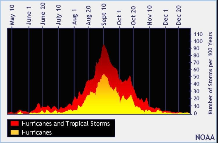
The peak of the season is September 10, with most activity occurring between mid-August and mid-October, the Hurricane Center said.
National Hurricane Center Map: What Are Forecasters Looking At Now?
Systems currently monitored by the National Hurricane Center include:
Nooooo
Embedded content: https://www.nhc.noaa.gov/xgtwo/two_atl_0d0.png?052051
Interactive map: hurricanes, tropical storms that have passed near your city
Excessive rainfall forecast
What’s next?
We will continue to update our tropical weather coverage daily. Download the app from your local site to ensure you’re always up to date with the news. And look here for our special subscription offers.
This article originally appeared in Treasure Coast Newspapers: NHC tracks 4 tropical waves. Florida is experiencing heavy rainfall


