


The tropics are warming and the National Hurricane Center is monitoring two disturbances in addition to potential tropical cyclone one, according to the latest advisory from the National Hurricane Center.
Tropical storm warnings are in effect for parts of Texas ahead of potential Tropical Cyclone One, which is expected to become a tropical storm before making landfall late Wednesday.
➤ Track all active storms
➤ Track potential Tropical Cyclone One
The major storm — with tropical storm force winds extending 290 miles northeast of the center — could be a rainmaker, bringing 2 to 4 inches of rain and up to 6 inches in some locations, according to the National Hurricane Center. AccuWeather predicted some areas could see up to 30 inches.
If it becomes a tropical storm, it will be the first named storm of the 2024 Atlantic hurricane season, Alberto. To become a tropical storm, maximum sustained winds must reach at least 60 km per hour.
Future Tropical Storm Alberto? Potential Tropical Cyclone One is expected to strengthen before landfall. See spaghetti models
The National Hurricane Center is also monitoring two other systems: a disturbance east of Florida with a low chance of development and another area in the southwestern Gulf of Mexico, close to where potential Tropical Cyclone One is located.
Here is the latest update from the NHC as of June 18 at 2 a.m.:
Potential tropical cyclone one
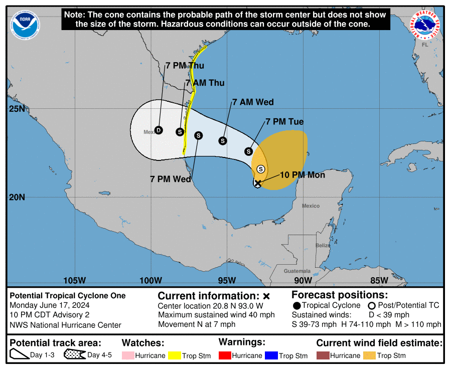
Special note about the NHC cone: The forecast track shows the most likely path from the center of the storm. It does not illustrate the full width of the storm or its effects, and the center of the storm is likely to move outside the cone up to 33% of the time.
-
Location: 350 miles southeast of Brownsville, Texas
-
Maximum wind speed: 40 mph
-
Direction: North at 6 mph
Prediction, impact: Potential Tropical Cyclone One is expected to strengthen before landfall. See spaghetti models
Spaghetti models for Potential Tropical Cyclone One
➤ Track potential Tropical Cyclone One
Special note about spaghetti models: Illustrations include a range of forecasting tools and models, and they are not all the same. The hurricane center uses only the four or five best-performing models to help make its forecasts.
What is there and how likely is it that they will strengthen?

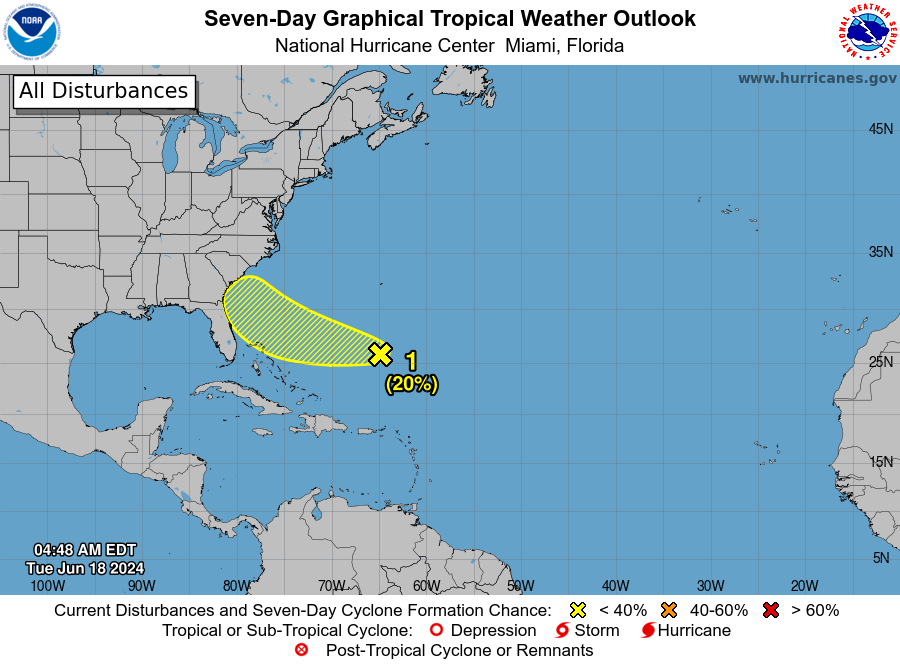
Southwest Atlantic Ocean: An area of clouds and showers several hundred miles east of the Bahamas is associated with a surface trough and an upper area of low pressure.
Environmental conditions could be conducive to gradual development of this system over the next few days as it moves west or west-northwest. The system is expected to approach the coast of the southeastern United States on Friday.
-
Probability of formation during 48 hours: low, 10 percent.
-
Formation chance during 7 days: low, 20 percent.
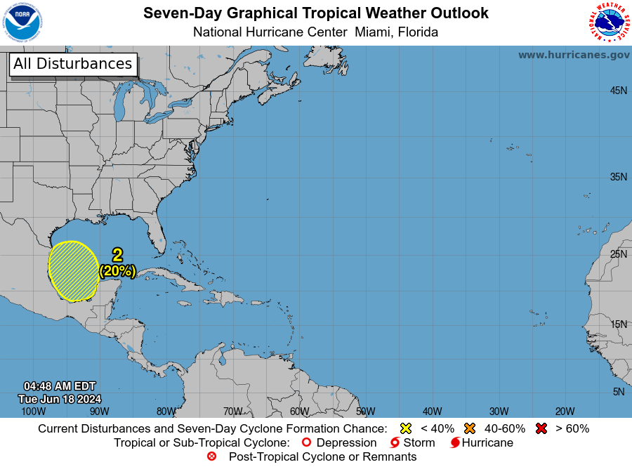
Southwest Gulf of Mexico: Another broad area of low pressure is forecast to develop over the southwestern Gulf of Mexico this weekend.
Environmental conditions are expected to be conducive to the gradual development of this system early next week as it slowly moves north or northwest.
“With warm water and low-level shear still present in the southern Gulf of Mexico and northwestern Caribbean next weekend, another opportunity for tropical development may arise,” said AccuWeather Senior Meteorologist Dan Pydynowski.
Depending on environmental conditions, “all moisture from this area could move back toward the Gulf Coast during the last week of June,” according to AccuWeather.
-
Probability of formation during 48 hours: low, almost 0 percent.
-
Formation chance during 7 days: low, 20 percent.
Who is likely to be affected?
Potential Tropical Cyclone One: This system is expected to strengthen and likely become a tropical storm Wednesday before approaching the western Gulf Coast late Wednesday. Tropical storm conditions are expected within the warning area on Wednesday.
Potential Tropical Cyclone One is expected to bring 2 to 4 inches of rain to South Texas and northeastern Mexico, with a possible chance of 6 inches, NHC forecasters said. AccuWeather forecasters said up to 30 inches are possible in some locations.
Weather Channel meteorologist Jim Cantore warned that “double-digit precipitation totals are likely along Texas’ coastal counties and possibly Houston.”

Atlantic Ocean: “This appears to be a fast-moving and compact area of low pressure that will move westward into northeastern Florida or perhaps as far north as southeastern Georgia on Thursday,” AccuWeather Senior Meteorologist Dan Pydynowski said.
A stronger storm could bring gusty winds, especially in coastal areas. A less organized storm would bring rough surf and downpours from the northern Bahamas to the southeast Atlantic coast, AccuWeather said.
Gulf of Mexico: “Depending on the wind pattern in the atmosphere, any moisture from this area could move back toward the Gulf Coast during the last week of June,” AccuWeather said. “Given the expected rainfall over the coming week, the risk of localized flooding may increase.”
Forecasters urge all residents to continue to monitor the tropics and always be prepared. That advice is especially important ahead of what is expected to be a very active hurricane season.
Weather watches and warnings issued in Florida
When is the Atlantic Hurricane Season?
The Atlantic hurricane season runs from June 1 to November 30.
When is the peak of hurricane season?

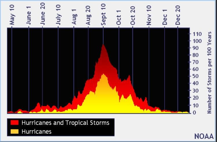
The peak of the season is September 10, with most activity occurring between mid-August and mid-October, the Hurricane Center said.
National Hurricane Center Map: What Are Forecasters Looking At Now?
Systems currently monitored by the National Hurricane Center include:
Interactive map: hurricanes, tropical storms that have passed near your city
Excessive rainfall forecast
What’s next?
We will continue to update our tropical weather coverage daily. Download the app from your local site to ensure you’re always up to date with the news. And look here for our special subscription offers.
This article originally appeared in Treasure Coast Newspapers: NHC tracking Potential Tropical Cyclone 1; 2 systems. Prediction, impact


