

Areas of Oklahoma are at risk of severe thunderstorms with large hail and damaging winds this evening, the National Weather Service in Norman said.
Here’s what you can expect on Tuesday.
Increased risk of severe weather events in Oklahoma City
The Oklahoma City metro, including Oklahoma and Cleveland counties, is at an increased risk for severe thunderstorms this evening.
Severe weather in central and western Oklahoma is expected to begin at 6 p.m. Severe weather is expected to begin in areas near Ardmore, Ada and Durant at 9 p.m.
Storms are expected to develop along and ahead of a cold front and dryline late this afternoon. Large to very large hail and damaging winds will be the biggest hazards, with a low tornado risk early tonight. #okwx #texomawx pic.twitter.com/tO7SseGSJZ
— NWS Norman (@NWSNorman) June 4, 2024
According to NWS Norman, Canadian County and western Oklahoma are at low risk.
The main hazards in these areas include hail up to baseball size, wind speeds over 80 miles per hour and low tornado potential, according to NWS Norman.
Possible flooding in Oklahoma Tuesday
Much of the Oklahoma City metro, including all of Oklahoma and Cleveland counties and eastern Canadian County, is at a moderate risk of flash flooding tonight.
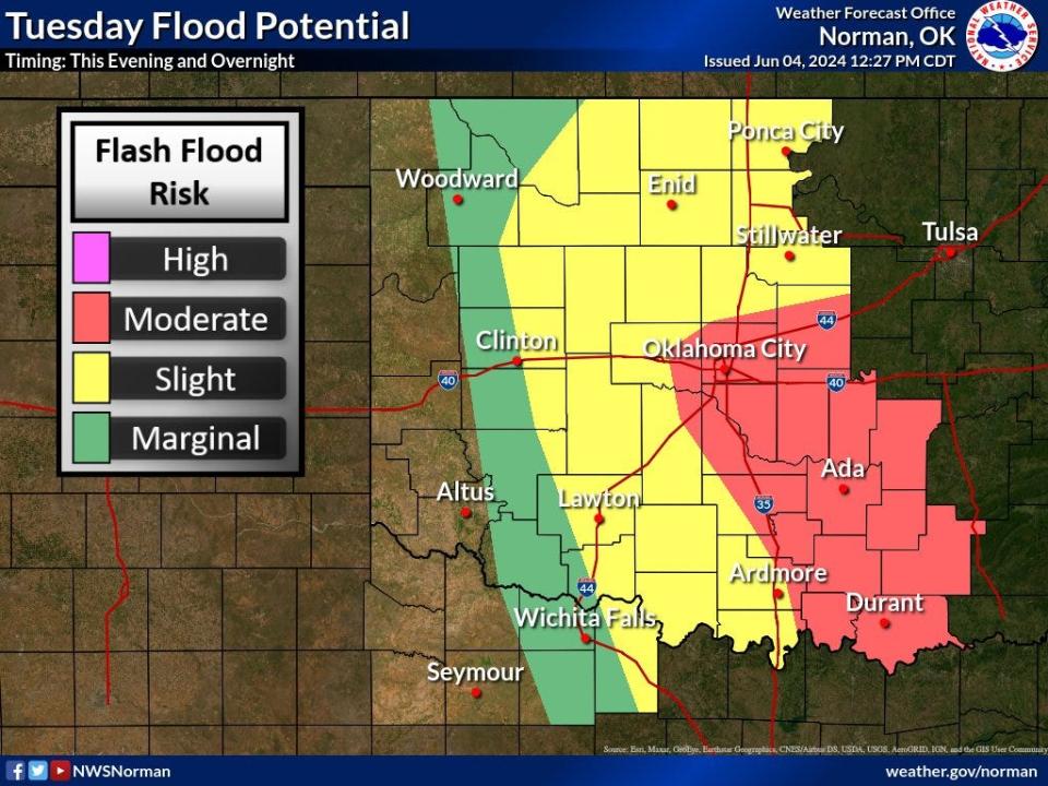
Areas west of the metro are at low risk, and a small portion of western Oklahoma is at marginal risk.
This article originally appeared on Oklahoman: Oklahoma weather: Severe thunderstorms, flood potential forecast


