

South Carolina could see some bad weather due to a potential tropical cyclone forming off the coast.
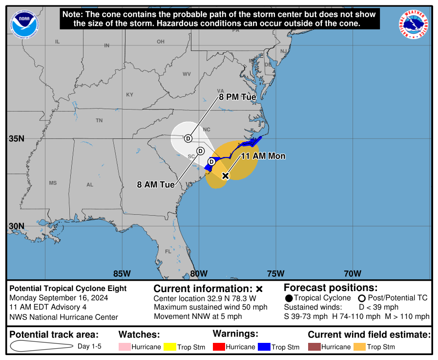
According to the National Hurricane Center, the weather was classified as a “low pressure area,” not yet a tropical storm, on Monday morning. The system strengthened as it tracked northwest toward the South Carolina coast, increasing its speed to 5 mph. About 100 miles east of Charleston, S.C., maximum sustained winds were 50 mph.
afternoon report
Here’s what you need to know about who will be affected by the low, the chance of a tropical storm, and more.
More: Rough Gems: How many WNC locations make a list of the best ‘undiscovered’ cities in NC?
Is a tropical storm developing?
The low’s chances of becoming a tropical storm have decreased as the storm’s structure became less organized in the early morning hours of Monday. Forecasters say maximum winds are expected to decrease as the storm approaches the coast.
If the system develops into a tropical storm, it will be named Helene, the next name on the list for 2024.
More: Tim Walz speaks in Asheville: What we know about road closures, timing and more
Who is affected by the storm?
A 300-mile stretch of coastline across NC and SC saw tropical storm warnings Monday morning, with forecasts of “gale-force winds, heavy rainfall and coastal flooding,” the National Hurricane Center said. An earlier tropical storm warning for a 100-mile stretch of the SC coast heading south was lifted at 11 a.m.
The advisory said areas hardest hit by the storm could receive up to 8 inches of rain, with some spots seeing as much as 10 inches. “A few” tornadoes are also possible across eastern parts of the Carolinas through Monday night.
“Locally significant flash and urban flooding” from the rainfall was also in the forecast, with the Carolinas already seeing some of these effects. The entire Mid-Atlantic region is at risk for isolated flooding, and rivers in southeastern NC and northeastern SC could experience minor flooding through Monday night.
More: Republican Mark Robinson, North Carolina gubernatorial candidate in Burnsville: ‘We’re right about everything’
Will Upstate be affected by the potential tropical storm?
A National Weather Service warning alerted Upstate SC to the storm. The NWS warned of heavy rains expected to begin Monday afternoon into Tuesday morning, with isolated flash flooding possible. Strong wind gusts are also possible Monday into Tuesday morning.
More: Rough Gems: How many WNC locations make a list of the best ‘undiscovered’ cities in NC?
Iris Seaton is the trending news reporter for the Asheville Citizen Times, part of the USA TODAY Network. Reach her at iseaton@citizentimes.com.
This article originally appeared on Asheville Citizen Times: Is a tropical storm forming? Severe weather hits the Carolinas


