


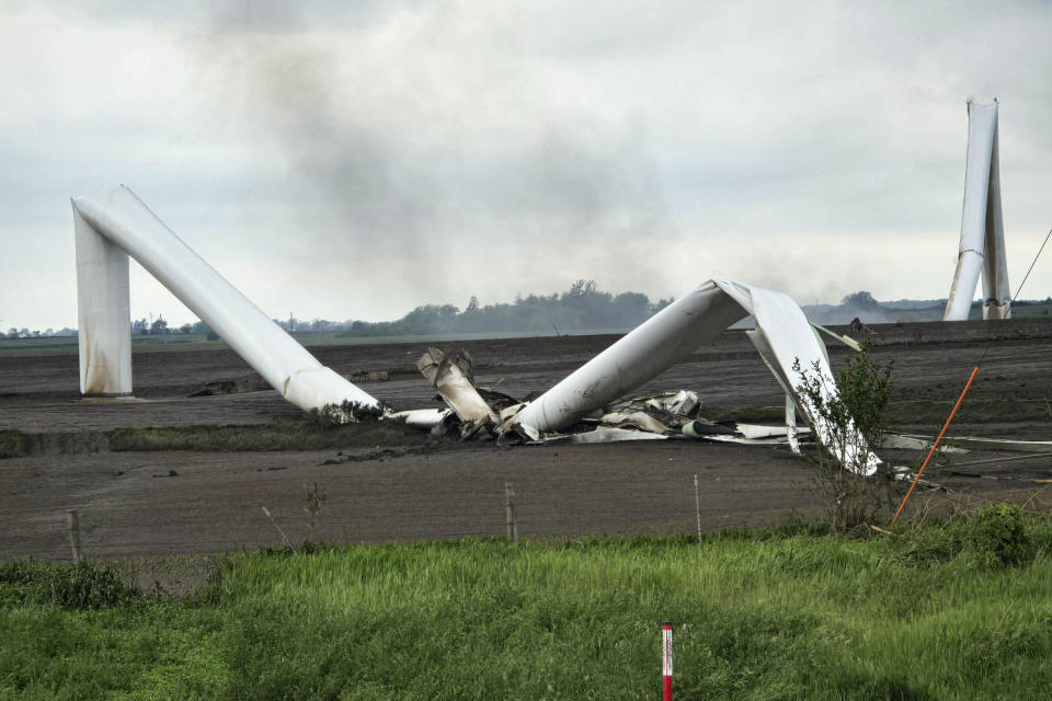
The tornado ripped through southern Iowa at nearly 45 mph, tearing up wind turbines like string cheese.
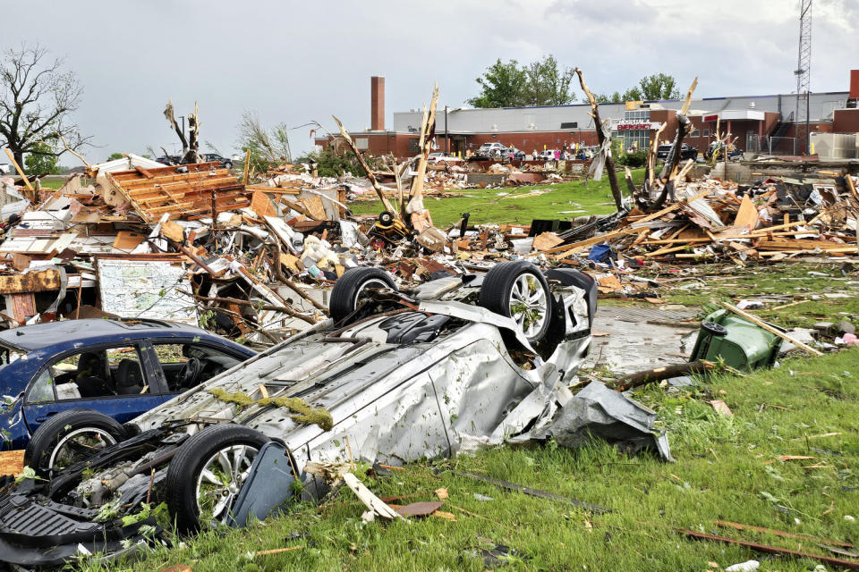
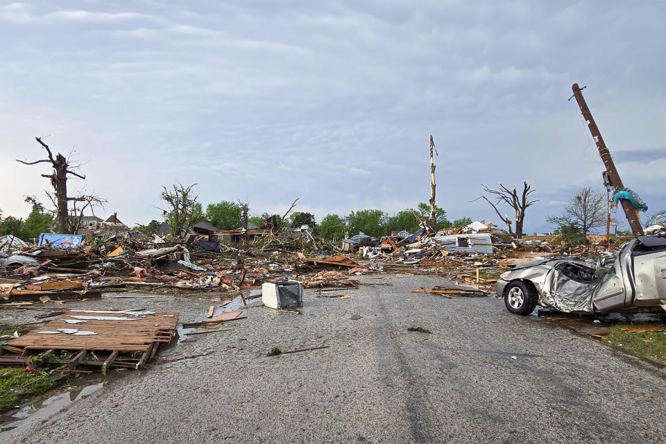
In the town of Greenfield, it overturned cars and tore houses from their foundations, leaving a rift of destruction visible from space. The twister, which the National Weather Service later rated EF4, killed five people on May 21, making it one of the deadliest so far this year, and injured 35.
More than a dozen tornadoes touched down in the state that day. While almost everyone in the area was in basements, a team of nine scientists – storm chasers – tried to get as close to the twisters as possible.
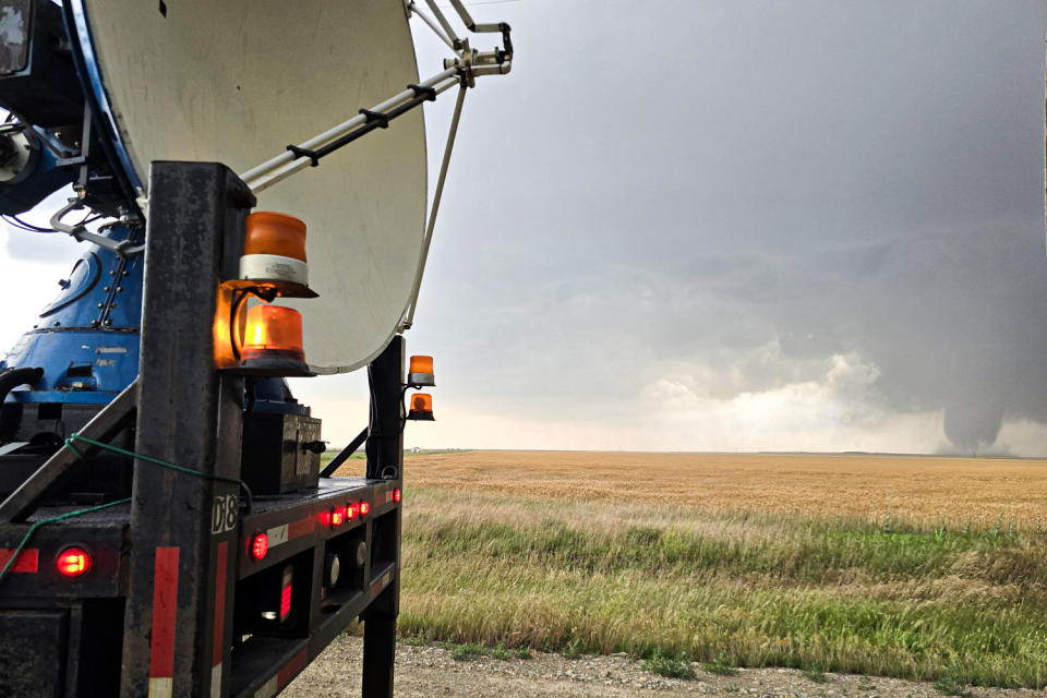
Just before 3 p.m. they saw their chance. When a tornado began appearing on their radar screens, the group sprang into action. They rushed one of their radar vans to a location about 10 miles west of Greenfield, a community of about 2,000 in southwestern Iowa.
Another team rushed to deploy a group of scientific instruments directly into the tornado’s path.
“Debris fell on us,” said Jennifer Walton, the team’s storm chaser and photographer.
A third truck drove through town, suddenly surrounded by trees and buildings blocking their radar view of the twister. They knew they were ahead of the storm; they didn’t know how much.
“That’s probably the most anxious time for all of us because we know a tornado is coming,” he said Joshua Wurman, a research scientist from the University of Illinois. “We really don’t know if it’s coming in five minutes, three minutes or two minutes.”
It worked. The team achieved an “intercept,” as they call it, by collecting data on the storm with the pod and two mobile radar equipment, giving scientists a rare, detailed, up-close view of one of the most powerful tornadoes ever seen this way. recorded.
The data they collected marks only the third time scientists have calculated wind speeds that exceeded 300 miles per hour within a tornado. And because the storm chasers took the measurements from multiple angles as the tornado ravaged Greenfield, the findings now provide a stark picture of the winds and inner dynamics of a vortex powerful enough to level houses.

“Tornadoes that cause this intensity and this type of damage are rare in the United States. We only get a handful of them every year,” said Tony Lyza, a physicist at the National Severe Storms Laboratory in Norman, Oklahoma, who was not involved in the study. “This is a very important study to show a tornado of this intensity and have mobile radar observe there while the tornado was causing the highest estimated damage.”
Many basic elements of tornado science remain uncertain because high-quality data is so difficult to obtain. These new findings could help untangle critical questions about the formation and structure of tornadoes, how wind speeds in the air correspond to damage on the ground, and the factors that can cause tornadoes to intensify or break off.
The team of nine researchers that headed to Greenfield on May 21 was led by Wurman and Karen Kosiba with the University of Illinois Flexible Array of Radars and Mesonets (FARM) team, which is funded in part by the National Science Foundation. The two are among the best academic storm chasers in the world.
The FARM researchers started the day in McCook, Nebraska, tired after a night of storms in Colorado, where they had caught only hailstones. The roving team travels with two radar cars and several other vehicles, including a pickup truck carrying a group of instruments designed to survive a tornado long enough to measure temperature, pressure and other factors. They left for Greenfield, a nearly six-hour drive.
Chasing a tornado is like playing a board game against nature. Researchers evaluate conditions, calculate probabilities, and move pieces—radar cars, balloons, and pods—so they can get the best reading of the storm from a relatively safe distance.
This kind of work can be deadly: In 2013, three tornado chasers died while chasing a powerful tornado in El Reno, Oklahoma.
In Iowa, the FARM researchers’ day started as a game of whack-a-mole. Storms moved quickly through the area, forcing them to guess where to position their equipment and how to maintain a safe distance. They found themselves weaving along country roads as storms appeared on the radar, only to watch them disappear.
But as the Greenfield tornado approached the city, ten minutes of intense action began.
“This is not a safe sport. You have to be able to make changes on the fly,” says Walton.
Kosiba and Wurman positioned their radar van about a mile east of downtown, about 1,000 feet from the edge of the twister. They lowered the truck’s metal hydraulic feet and lifted the wheels to create a stable, level platform that could weather the storm.
“We don’t want to bounce back and forth and confuse our radar,” Wurman said.
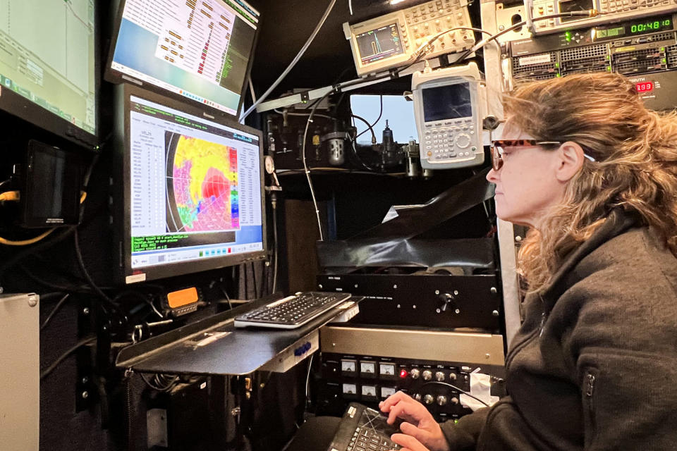
The wind whipped through the truck at about 80 miles per hour, but the researchers can’t remember much of what it looked like outside: They were glued to their screens.
“I never look out the window,” Kosiba said. “I always look at the radar.”
The truck sends out a narrow beam of radar waves that hit objects flying through the air, from raindrops to two-by-fours. The device measures the energy returning and provides data so detailed that researchers can understand the shape of falling raindrops.
Inside the truck, they watched colors flash across the displays as the tornado splintered the frames of houses and tore apart trees.
At times, several vortices swirled within the tornado, which lasted about 45 minutes and traveled about 45 miles. For less than a second, researchers calculated wind speeds of more than 300 miles per hour in one part of the tornado.
“This was a violent day in Iowa,” said Tim Marshall, a veteran storm chaser from Texas who was not involved in the study.
According to the weather service, the twister was at times as wide as 1,000 feet. But when it hit Greenfield, it had shrunk. Scientists don’t know exactly why that happened; it’s one of many mysteries that this kind of detailed radar data could ultimately help solve.
“We’re going to be chewing on this for years to come,” Wurman said.
The ingredients needed to form a tornado – wind shear, lift, instability and moisture – are well known and allow forecasters to issue reliable tornado watches, but much else remains mysterious.
“Once a storm forms and produces a tornado, we have very little ability to know whether that tornado will be large or small, long-lived or short-lived, or the exact path that storm will follow,” says Wurman. said.
Storm chasers perform their dangerous dance with the elements to push their field forward.
Recent measurements from the Greenfield tornado in particular could provide insight into how wind speeds aloft translate into damage on the ground. Kosiba plans to correlate the detailed wind speed data her team has collected with ground damage surveys. She also plans to model the thermodynamics of the event, which could provide clues about what factors could lead to more intense wind speeds.
This work could help scientists develop better tornado forecasting systems and help builders build more resilient structures.
“We don’t want to see the destruction, but this is how we learn,” Marshall said. “The damage is Mother Nature’s fingerprint. This is how we evaluate how it happened.”
This article was originally published on NBCNews.com


