


For the third day in a row, an earthquake rumbled in South Carolina. But unlike the two quakes recorded in the Columbia area over the weekend, Monday’s quake struck a different part of the Palmetto State.
A magnitude 2.2 earthquake was recorded Monday morning in Chesterfield County, according to the U.S. Geological Survey. The previous quakes struck the Midlands region on Saturday and Sunday, while this one was closer to the North Carolina state line.
Monday’s quake was confirmed at 12:53 a.m. near Pageland, the South Carolina Emergency Management Division said. It struck about a mile below the surface, the USGS said.
This was the 15and confirmed earthquake in South Carolina this year, after 28 earthquakes were recorded in 2023, the state Department of Natural Resources said.
A 2.1 magnitude quake struck Saturday afternoon and was followed by a 2.5 magnitude quake Sunday night, the USGS reported. Both quakes were recorded in the Elgin area of Kershaw County, the USGS said.
Before this recent series of quakes, the last time seismic activity was recorded in South Carolina was on Sept. 1, when a magnitude 2.1 earthquake struck in McCormick County, according to data from the state Department of Natural Resources.
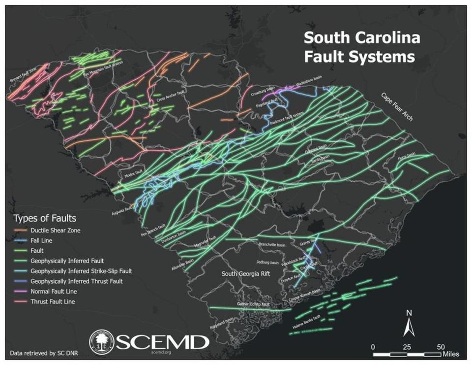
History of earthquakes in SC
It’s not often that earthquakes occur outside the Midlands region of the Palmetto State, especially outside of Kershaw County. According to the South Carolina DNR, 64 earthquakes have been confirmed there since late June 2022.
That’s also where the most powerful earthquakes in recent times in South Carolina were recorded: on June 29, 2022.
That day, two earthquakes — one 3.5 and the other 3.6 — struck in a flurry of tremors and aftershocks. They were the two largest earthquakes to hit South Carolina in nearly a decade. A 4.1 quake struck McCormick County in 2014.
Anyone who felt vibrations, tremors or heard rumbling noises as a result of Monday morning’s earthquake can report them to the USGS.

The latest quake makes at least 119 detected in the Palmetto State since the start of 2022, according to the South Carolina DNR. All but 14 of the quakes were in the Midlands.
According to the DNR, a total of 111 earthquakes have occurred in the Columbia area since the magnitude 3.3 earthquake on December 27, 2021.
The SC Emergency Management Division said Monday morning earthquake was classified as a microquakeaccording to the Modified Mercalli Intensity Scale.
No major damage or injuries have been reported from the recent earthquakes.
Earthquakes with a magnitude of 2.5 or less often go unnoticed and are typically only recorded by a seismograph, according to Michigan Technological University. An earthquake with a magnitude of less than 5.5 is unlikely to cause significant damage, the school said.
It used to be common for South Carolina to have between six and 10 earthquakes a year, the S.C. Geological Survey previously reported. According to the DNR, there have been 133 earthquakes in South Carolina since Jan. 18, 2021.
At a 2022 meeting to discuss the earthquakes, state geologist Scott Howard said there may be as many as 200 smaller quakes that went unnoticed and unrecorded.
Why is there an increase in earthquakes?
Scientists still have no explanation for the eruption.
Some experts have theorized that there is a connection between the Wateree River and the earthquakes northeast of Columbia. They said that the combination of a single moderate earthquake in December 2022 and high water levels in the Wateree River during parts of 2022 and 2023 contributed to the quakes.
There is still no clear cause for the earthquakes in the Midlands.
Elgin, about 20 miles (32 kilometers) northeast of Columbia and located on a fault line, was hit by an unusual earthquake swarm, leaving some residents feeling uneasy.
The series of quakes could be the longest period of earthquake activity in the state’s history, officials said. But they do not believe the series of small quakes is an indication that a larger quake is coming.
“While the frequency of these small earthquakes may alarm some, we do not anticipate a significant damage earthquake in South Carolina at this time, even though we know our state has had them decades ago,” Kim Stenson, director of South Carolina EMD, said earlier in a press release.
“Now is the time to review your insurance policies for earthquake coverage, secure any items in your home that could pose a hazard during a quake, and remember to fall, cover, and hold on until the quake passes. Here are the precautions South Carolinians can take to prepare for earthquakes.”
The largest earthquake ever recorded in South Carolina and on the East Coast of the United States was a devastating magnitude 7.3 quake in Charleston in 1886.
According to the state EMD, the quake killed 60 people and was felt over 2.5 million square miles (6.5 million square kilometers), from Cuba to New York and from Bermuda to the Mississippi River.
Reported earthquakes in SC in 2021-24
|
Date/Location |
Size |
Depth (km) |
|
2021 |
||
|
January 18/Dalzell |
2.1 |
6.9 |
|
February 13/Summerville |
2.1 |
5.1 |
|
May 12/Heath Springs |
1.8 |
9.99 |
|
May 31/Top |
2.6 |
1.7 |
|
May 31/Top |
2.0 |
5.1 |
|
July 16/Ladson |
2.0 |
4.0 |
|
July 22/Ladson |
1.3 |
3.5 |
|
July 22/Ladson |
1.95 |
3.97 |
|
August 21/Centerville |
1.75 |
1.97 |
|
August 21/Centerville |
1.71 |
3.37 |
|
September 27/Summerville |
2.8 |
6.0 |
|
September 27/Summerville |
2.0 |
5.8 |
|
September 27/Centerville |
3.3 |
6.8 |
|
Oct 25/Jenkinsville |
2.2 |
3.8 |
|
Oct 26/Jenkinsville |
1.8 |
0.0 |
|
Oct 28/Jenkinsville |
1.8 |
1.8 |
|
Oct 28/Jenkinsville |
1.7 |
0.0 |
|
Oct 28/Jenkinsville |
2.1 |
4.2 |
|
Oct 31/Jenkinsville |
2.3 |
0.1 |
|
November 1/Jenkinsville |
2.0 |
5.1 |
|
November 9/Centerville |
1.5 |
3.8 |
|
November 16/Arial |
2.2 |
5.4 |
|
Dec 20/Ladson |
1.1 |
2.8 |
|
Dec 27/Lugoff |
3.3 |
3.2 |
|
Dec 27/Lugoff |
2.5 |
2.4 |
|
Dec 27/Elgin |
2.1 |
0.7 |
|
Dec 27/Lugoff |
1.7 |
4.9 |
|
Dec 29/Elgin |
2.3 |
1.6 |
|
Dec 30/Elgin |
2.5 |
2.5 |
|
Dec 30/Elgin |
2.4 |
3.8 |
|
2022 |
||
|
January 3/Lugoff |
2.5 |
2.7 |
|
January 5/Lugoff |
2.6 |
0.5 |
|
January 5/Lugoff |
1.5 |
7.0 |
|
January 9/Ladson |
1.4 |
2.9 |
|
January 11/Elgin |
1.7 |
5.4 |
|
January 11/Lugoff |
2.0 |
3.2 |
|
January 11/Elgin |
1.3 |
5.0 |
|
January 15/Elgin |
1.8 |
3.5 |
|
January 19/Elgin |
1.9 |
5.0 |
|
January 21/Elgin |
1.9 |
4.8 |
|
Jan 27/Lugoff |
2.1 |
1.0 |
|
February 2/Elgin |
1.5 |
3.9 |
|
March 4/Elgin |
1.8 |
2.8 |
|
March 9/Elgin |
2.2 |
3.6 |
|
March 11/Camden |
2.1 |
1.2 |
|
March 27/Lugoff |
2.1 |
1.9 |
|
March 28/Centerville |
0.9 |
2.9 |
|
April 7/Elgin |
2.0 |
2.9 |
|
April 8/Centerville |
1.6 |
3.6 |
|
April 22/Ladson |
1.1 |
3.5 |
|
April 22/Taylors |
2.2 |
2.3 |
|
May 9/Elgin |
3.3 |
3.1 |
|
May 9/Elgin |
1.6 |
2.9 |
|
May 9/Elgin |
1.78 |
4.1 |
|
May 9/Elgin |
2.1 |
3.7 |
|
May 9/Elgin |
2.9 |
5.6 |
|
May 10/Elgin |
2.3 |
3.9 |
|
May 10/Elgin |
2.8 |
6.2 |
|
May 19/Elgin |
1.8 |
2.5 |
|
May 21/Elgin |
1.9 |
5.6 |
|
June 26/Elgin |
1.88 |
4.09 |
|
June 29/Elgin |
3.5 |
2.64 |
|
June 29/Elgin |
1.88 |
2.92 |
|
June 29/Elgin |
3.6 |
2.95 |
|
June 29/Elgin |
1.79 |
2.07 |
|
June 29/Elgin |
1.51 |
3.72 |
|
June 29/Elgin |
1.46 |
1.93 |
|
June 29/Elgin |
2.06 |
2.22 |
|
June 30/Elgin |
2.32 |
3.09 |
|
June 30/Elgin |
1.44 |
2.8 |
|
June 30/Elgin |
2.03 |
3.11 |
|
June 30/Elgin |
2.15 |
2.56 |
|
June 30/Elgin |
2.06 |
1.92 |
|
June 30/Elgin |
1.49 |
2.46 |
|
July 1/Elgin |
1.55 |
3.37 |
|
July 1/Elgin |
2.11 |
3.83 |
|
July 1/Elgin |
1.26 |
3.3 |
|
July 1/Elgin |
1.68 |
4.02 |
|
July 2/Elgin |
2.09 |
1.65 |
|
July 3/Elgin |
1.9 |
2.1 |
|
July 3/Lugoff |
1.6 |
3.2 |
|
July 3/Elgin |
1.4 |
1.96 |
|
July 3/Elgin |
1.1 |
5.0 |
|
July 7/Elgin |
2.1 |
4.0 |
|
July 8/Elgin |
1.6 |
2.5 |
|
July 8/Elgin |
1.4 |
3.8 |
|
July 14/Elgin |
1.3 |
2.5 |
|
July 15/Elgin |
1.6 |
3.3 |
|
July 18/Elgin |
1.2 |
3.2 |
|
July 19/Elgin |
2.2 |
1.8 |
|
July 19/Elgin |
2.1 |
3.2 |
|
July 24/Lugoff |
2.3 |
2.4 |
|
July 25/Lugoff |
2.1 |
2.2 |
|
July 30/Elgin |
1.8 |
3.6 |
|
July 31/Elgin |
1.7 |
1.6 |
|
August 3/Elgin |
1.8 |
3.0 |
|
August 9/Boykin |
1.6 |
6.9 |
|
August 15/Elgin |
1.5 |
3.6 |
|
August 18/Homeland Park |
2.1 |
0.03 |
|
August 27/Elgin |
1.3 |
2.4 |
|
September 1/Centerville |
1.5 |
0.7 |
|
September 21/Elgin |
1.9 |
3.2 |
|
September 22/Lugoff |
1.4 |
1.5 |
|
Oct 14/Elgin |
1.3 |
4.2 |
|
Oct 30/Elgin |
2.5 |
0.02 |
|
November 24/Elgin |
2.0 |
3.5 |
|
December 9/Elgin |
1.7 |
2.4 |
|
2023 |
||
|
January 10/Hopkins |
1.9 |
6.0 |
|
January 18/Centerville |
1.4 |
8.8 |
|
January 20/Lugoff |
1.8 |
4.5 |
|
February 17/Cayce |
1.9 |
5.0 |
|
February 17/Elgin |
2.4 |
2.4 |
|
February 28/Elgin |
1.3 |
2.5 |
|
March 27/Winnsboro |
1.4 |
4.5 |
|
April 4/Cross Anchor |
1.6 |
11.5 |
|
June 5/Elgin |
1.72 |
3.6 |
|
June 20/Elgin |
2.0 |
3.4 |
|
July 24/Ladson |
2.5 |
6.4 |
|
Aug 3/Six Miles |
1.9 |
5.6 |
|
August 5/Summerville |
1.72 |
4.83 |
|
Oct 6/Kershaw County |
2.2 |
2.9 |
|
Oct 9/Elgin |
1.68 |
4.67 |
|
November 17/Jenkinsville |
1.8 |
3.4 |
|
November 19/Jenkinsville |
1.7 |
11.6 |
|
November 21/Jenkinsville |
1.6 |
5.4 |
|
November 26/Jenkinsville |
2.2 |
4.0 |
|
November 26/Jenkinsville |
2.09 |
6.34 |
|
November 27/Jenkinsville |
1.86 |
5.67 |
|
November 29/Jenkinsville |
2.0 |
4.6 |
|
November 29/Jenkinsville |
2.01 |
1.8 |
|
November 30/Jenkinsville |
2.41 |
2.87 |
|
December 13/Jenkinsville |
1.6 |
6.41 |
|
Dec 22/Lugoff |
2.2 |
2.4 |
|
Dec 28/Jenkinsville |
1.8 |
1.6 |
|
Dec 30/Elgin |
2.1 |
4.4 |
|
2024 |
||
|
January 8/Elgin |
2.1 |
3.2 |
|
February 6/Lugoff |
1.7 |
1.7 |
|
March 9/Elgin |
2.83 |
2.86 |
|
March 9/Elgin |
1.3 |
1.5 |
|
March 17/Elgin |
1.9 |
2.9 |
|
March 24/Elgin |
2.1 |
4.9 |
|
March 27/Elgin |
2.2 |
6 |
|
April 6/Jenkinsville |
1.2 |
5.1 |
|
June 11/Lesslie |
2.2 |
2.8 |
|
August 9/Elgin |
2.3 |
3.9 |
|
August 26/Jackson |
1.9 |
0.7 |
|
September 1/Parksville |
2.1 |
5.6 |
|
September 14/Elgin |
2.1 |
3.2 |
|
September 15/Elgin |
2.5 |
2.3 |
|
September 16/Pageland |
2.2 |
1.9 |


