


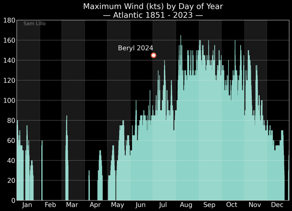
Earliest Category 5 in the Atlantic. Earliest Category 4. Strongest hurricane of June. Easternmost hurricane of June. First system to rapidly intensify in the Atlantic in June. All new hurricane book rewrites began in 1851.
Beryl, only the second named storm of 2024, is an eye-opener for what meteorologists have been predicting will be one of the busiest — and scariest — hurricane seasons on record. The next few months are historically more active. And for the second year in a row, hurricane breeding grounds in the Atlantic Ocean, Caribbean Sea and Gulf of Mexico all contain the superfuel of hurricane engines — extremely hot ocean water.
For hurricane experts, Beryl’s historic, rapid development is both an extreme example of the kind of monster storms that can form under current climate conditions and a signal of what may happen more often as global and ocean warming continues.
“This is an outlier by any measure,” said David Zierdan, Florida’s state climatologist. “And that doesn’t mean it’s the new norm, that it’s going to happen every year. But is climate change playing a role? I’m sure it is.”
Climate connection
Scientists are still unraveling all the intricate ways climate change is affecting hurricanes, and they stress that no storm, even a record-breaker like Beryl, can be attributed solely to ongoing climate change. Of course, there have been more powerful storms in the past — just not this early in the season.
However, they are most confident in a number of specific changes that have already been observed in hurricanes: higher sea levels lead to more storm surges and rainfall in hurricanes, warmer seas mean storms can become stronger, and warmer seas increase the chance that a storm will quickly intensify.
And right now, for the second year in a row, the Atlantic and Caribbean are hotter than ever before in the record books. Scientists say it’s likely due to a number of factors, including a volcanic eruption that shot water vapor into the atmosphere, weaker trade winds across the Atlantic and — bizarrely — a successful effort to reduce air pollution from ships crossing the Atlantic.
But the very largest piece of the pie, Zierdan says, is the well-documented impacts of climate change.
The other impacts are “very minor compared to the biggest culprit, which is greenhouse gases and overall planetary warming,” he said.
READ MORE: What we know – and don’t know – about the impact of climate change on hurricanes
Whatever combination of factors were at play, Beryl met and even exceeded the official standard for rapid intensification last weekend, when the hurricane reached 65 mph sustained winds in 24 hours.
It was the first storm ever to reach that level of intensification, and in a spot in the Caribbean where rapid intensification often doesn’t happen until much later in the season, said Kieran Bhatia, senior vice president at insurance broker Guy Carpenter and author of several scientific papers on rapid intensification.
“No storm before Beryl had reached 65 mph of intensification before July. Forget the location in the Atlantic, this is all over the Atlantic,” he said. “It’s like redefining what typical behavior is. It’s really eye-opening.”
Animation of Hurricane Beryl’s intensity development, alongside GOES-East infrared satellite imagery of the storm that followed it, from 18 UTC June 28 to 12 UTC July 2.
The short period of attenuation shown in this graph was associated with an orbital wall replacement cycle (ERC). photo.twitter.com/5DI5TCNzMb
— Dr. Kim Wood (@DrKimWood) July 2, 2024
Bhatia’s research has shown that rapid intensification is becoming more common in storms in the Atlantic basin, and climate change could be the reason for this, particularly due to global warming caused by water.
“On average, storms that originate in areas with higher ocean heat content and sea surface temperatures are more likely to intensify,” he said.
However, he noted that it is very difficult to cross the line and say with certainty that climate change “caused” one event. Not without feeding thousands of years of weather data into global computer models, he said.
That’s why scientists are waiting for the results of what are known as climate attribution studies that do just that. So it may be a while before we have a scientific answer to the question of how climate change has affected a powerful storm like Beryl.
“Would I say this is something that’s going to happen for the rest of the year? I don’t know. The likelihood is increasing,” Bhatia said.
There are trends that suggest that rising ocean temperatures are already affecting storm development. For example, 10 of the 15 most active seasons for named storms have occurred since 2000 — but so has the ability to spot and measure them with satellites and other technology. For major storms of Category 3 or higher, the impact is not dramatic. Only 2005 ranked in the top eight years for major hurricane production, with 7 storms. The number one year for major storms was 1950, with eight. Six other years tied with 6 major storms, all before 2000, including 1926.
Beryl, the record breaker
Beryl was certainly a storm for the record books. It exploded from tropical depression to Category 5 monster in just three days, much earlier in the season than meteorological records suggest. It beat out Hurricane Emily, in 2005, for the top spot as the earliest July hurricane on record by a full two weeks.
It took just 48 hours to grow from a tropical depression to a Category 4 storm. Only three other storms have done that: Hurricane Keith in 2000, Hurricane Wilma in 2005 and Hurricane Delta in 2020.
Sam Lillo, a meteorologist who follows Beryl, said it was the first storm to accelerate that transition. The other three storms didn’t do so until September and October, closer to the peak of the season.
“Beryl is doing this two months before these other extremes happen,” said Lillo, a senior software engineer at the private weather service DTN Weather.

Beryl also joins a rare group of powerful storms that have battered the southern tip of the eastern Caribbean, including Grenada and St. Vincent and the Grenadines. According to NOAA’s historical hurricane database, the only other major storms to pass within 80 miles of the islands were Hurricane Ivan in 2004 and Hurricane Allen in 1980, both of which were considered Category 3 storms.
“If we ignore the time of year, this is already unique in terms of intensity in this area,” Lillo said.
Hurricane Beryl formed in a patch of ocean that was ideally suited for severe storms. Apart from the abnormally hot water, there was little storm shear to knock down the high, straight core of the hurricane. And the Saharan Dust sweeping across the Atlantic, which normally sneaks hot, dry air into storms and slows them down, had formed a small vortex around the site where Beryl formed, giving it a hot, moist place to grow with little interruption.
“To reach or maintain Category 5 strength, the perfect combination of factors is needed. That is what we are seeing now,” Zierdan said.
For those reasons, Zierdan and Lillo said, Beryl was an anomaly of a storm. Still, it was no surprise to meteorologists monitoring the signs for this hurricane season. Lillo called Beryl “a very likely historical event.”
While a storm like Beryl needs several things to strengthen to the rare echelon of Category 5, experts said one of the key ingredients in the mix is hot water. And there’s plenty of that in the Atlantic right now.
Water temperatures over the past month have remained steady at levels normally seen in September, the peak of the season. And that’s not just the sea surface temperatures, but also the upper 2,000 meters of water, known as the ocean’s heat content.

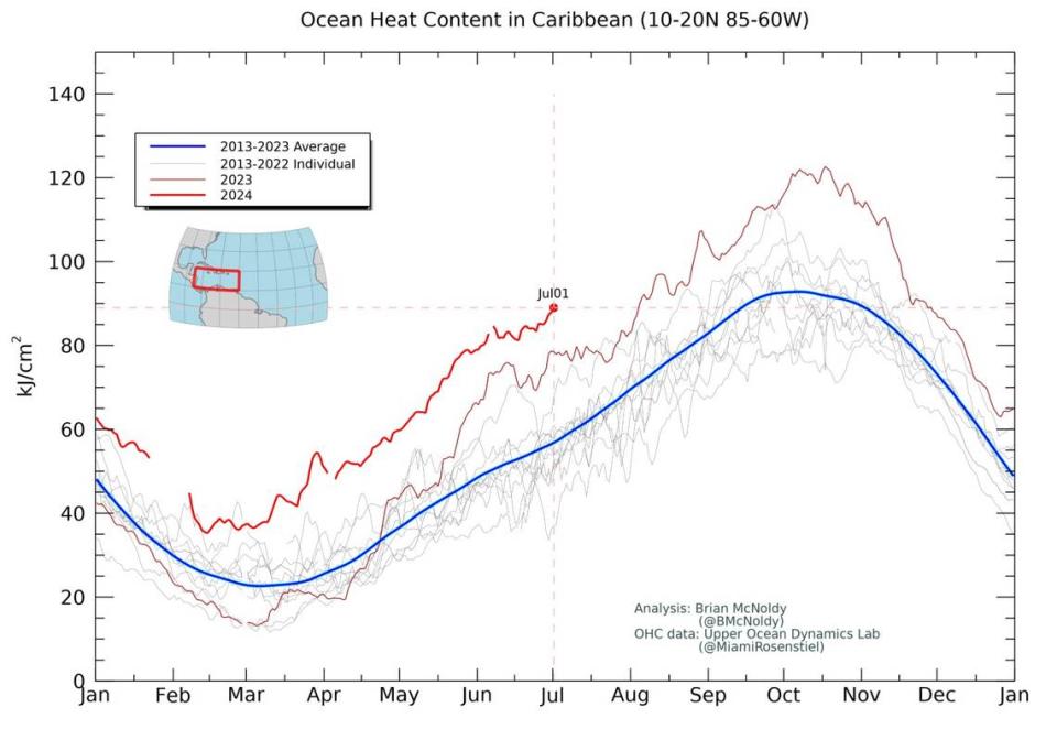
Hot water provides moisture for the hot, wet storm clouds that hurricanes wrap around their cores. The hotter the water, the greater the chance of very severe storms.
“It’s really the warm ocean temperatures that are 2 or 3 degrees Fahrenheit above normal,” Lillo said. “That little bit is enough to make a huge difference in how strong a storm gets.”
Last year, meteorologists said the main factors making the hurricane season so active were record-high water temperatures that sped things up, and a global weather phenomenon called El Niño that created extra wind shear, slowing storm activity somewhat.
This year, El Niño is gone. And NOAA scientists said there’s a 65 percent chance it will be replaced by the opposite phenomenon, La Niña, during the height of hurricane season — July through September. La Niña is associated with low wind shear in the Atlantic Ocean, making it easier for storms to form and grow stronger.
According to Lillo, storms in 2023 mainly occurred during the rare periods when wind shear decreased enough to take advantage of all that warm water.
“This year we expect those windows to be much larger and more frequent,” he said.


