


UPDATE on Monday at 4pm ET
The tropics are on pause for now. Dust from the Sahara dominates the tropical Atlantic Ocean. Although robust tropical disturbances leave Africa, they are unable to develop as they move westward. The dust normally peaks in late June and July, so this is not unexpected. So far this year, slightly less dust has fallen than normal, but now the density of the dust is about average.
The National Hurricane Center is identifying one of the African disturbances to watch as it reaches the western Caribbean late this week. The atmospheric pattern at that time is predicted to be conducive to development, and the system will have moved beyond the dust.
The Hurricane Center currently gives the disturbance a low chance of developing. The time frame we’re talking about is over this coming weekend. A blocking high-pressure system is forecast to develop across the southern US. This should keep any development well south.

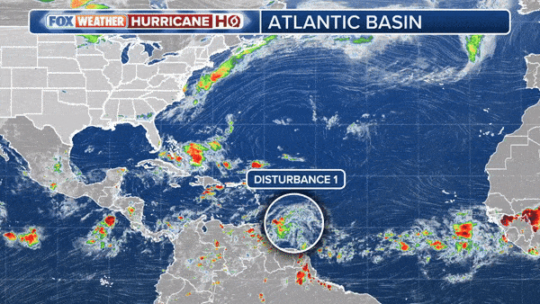
Tropical Storm Alberto and the two disturbances that couldn’t quite organize are the types of systems we expect to see in June. If a disturbance originating over Africa is allowed to develop, it usually does so after it has passed the Caribbean islands.
There’s nothing to watch for now, but we’ll keep an eye on it this week. Long-range computer forecast models indicate that the overall atmospheric pattern could be more favorable for development around the end of the month or early July. We will see.
Sahara dust consists of small particles from the Sahara Desert that are lifted into the atmosphere by strong winds. This dust can travel thousands of miles across the Atlantic Ocean, all the way to America. When Saharan dust is present in the atmosphere, it creates a dry and stable layer, making it difficult for thunderstorms to organize and develop into tropical storms or hurricanes. This phenomenon is called the Saharan Air Layer (SAL).

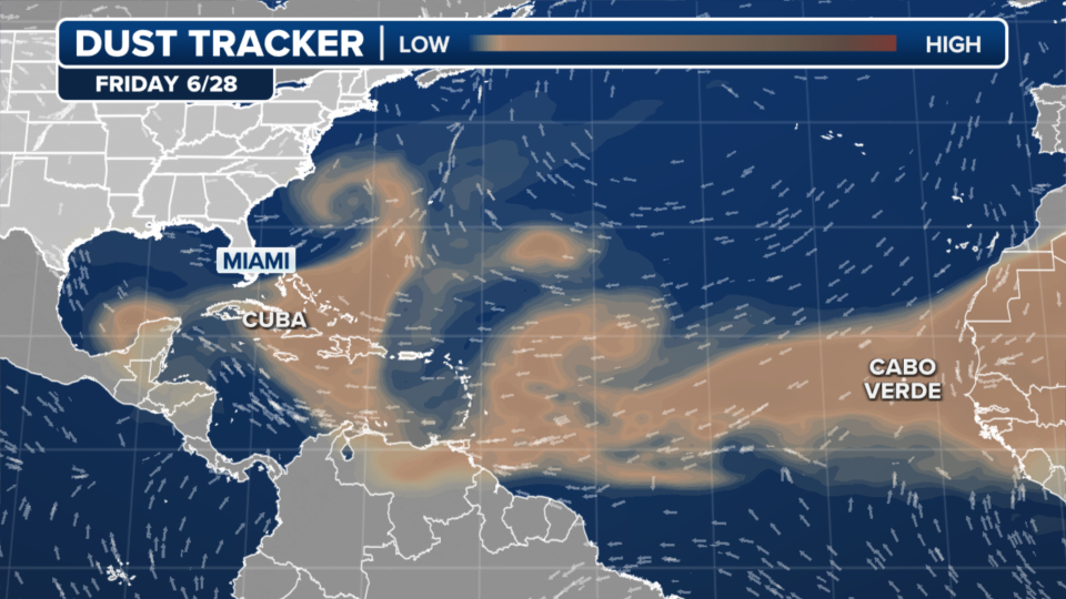
This year there is slightly less Saharan dust than normal. This fluctuation can be attributed to different atmospheric conditions and changes in wind patterns. Factors such as the strength and position of the large high-pressure system that dominates the Atlantic Ocean, as well as the temperature and humidity levels over the Sahara, can affect the amount of dust lifted into the atmosphere. Currently, dust levels are back to about average.
Tropical disturbances, which often start as clusters of thunderstorms, can develop into more organized systems such as tropical depressions, storms or hurricanes under the right conditions. Key factors for its development include warm ocean water temperatures, favorable upper winds and high humidity in the mid-atmosphere. When these conditions are met, the disturbances can consolidate and strengthen as they move across the ocean.
The Climate Prediction Center (CPC) formulates long-term forecasts using a combination of global climate models and observational data. These models include various atmospheric and oceanic variables, such as ocean water temperatures, wind patterns and moisture levels. By running atmospheric simulations multiple times to represent different scenarios, the CPC can make probabilistic predictions for tropical weather development. Historical data and current observations are also used to refine these predictions. The result tells us where and when to look for potential tropical activity up to 3 weeks in advance.
Editor’s note: Parts of this story were written using artificial intelligence.
Source of original article: Bryan Norcross: Something to watch at the end of the week


